29 May 2021
To mark National Walking Month, here are some of the best former rail routes you can walk along in Wales, chosen by our guest contributors.
During the nineteenth century, an extensive network of railway lines was built throughout Wales, transporting people and freight from place to place in the days before the motor vehicle. But by the middle of the twentieth century, many of these lines had seen a significant drop in demand and were closed. The tracks were torn up, stations were demolished and the land put to new use.
However, a number of former rail routes throughout the country can still be travelled on by foot or cycle. Today they serve as an important part of our extensive network of active travel routes, providing sustainable ways of exploring the beautiful Welsh countryside or getting from A to B.
Paul and Rebecca Whitewick, video content creators – Aberystwyth to Carmarthen
We spend a significant amount of our time trekking around the UK visiting old abandoned railways and canals. If you have a look at any old map you’ll find that there were quite a few disused lines in Wales.
We are firm believers that the conversion of much of this long-forgotten infrastructure to modern community use has a massive impact on not only how people use their local environment but also has the ability to become a long term asset for the area. These lines in our landscape created by our ancestors have the ability to help communities reconnect today in a very green way, creating open spaces, walkways and cycle-routes alike.
One of our favourite routes that we have covered to date is the Manchester and Milford Railway. Despite its namesake and original grand aspiration, it ultimately connected Carmarthen to Aberystwyth. Much of the route can be traced today using National Cycle Network routes 81 and 82.
Our journey started at the northern end near Llanilar where the joy of cycling between the old platforms is there for one to savour. The journey continues south-east until you arrive at Strata Florida. Here the line was supposed to have headed north to link up with the Mid Wales Railway at Llangurig, connecting Carmarthen, Lampeter and Llanidloes. A tunnel between Llanidloes and Strata Florida was said to have been started, marked on old maps with the words “Quarry” at either end, leaving a mystery for us to solve another day.
Turning south-west at Strata Florida here the journey now picks up NCN route 82, the line following the valley and the Afon Teifi for some considerable miles before you reach some of the old stations on the south of the line.
You can follow Paul and Rebecca’s adventures on their YouTube channel here – keep an eye out for new videos on abandoned railways in Wales very soon…
Glyn Evans, TfW Active Travel Advisor – Prestatyn to Dyserth
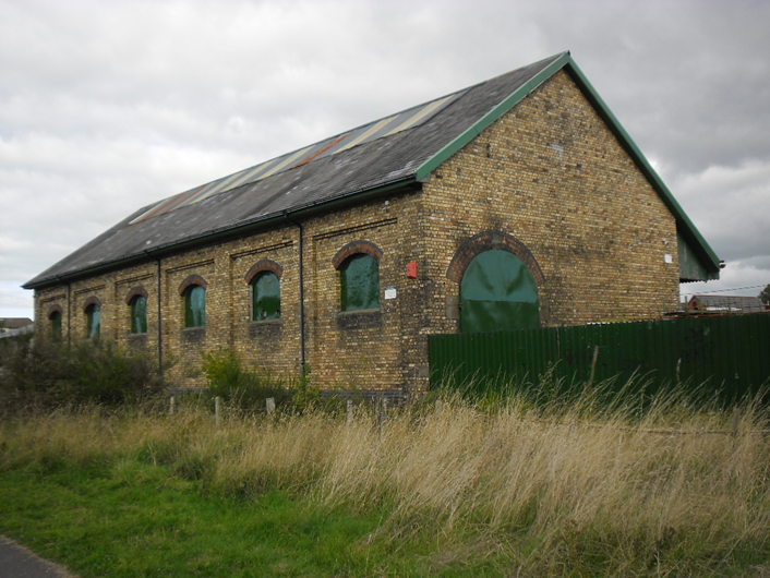
The Prestatyn – Dyserth Way is a hidden gem that runs right through the centre of Prestatyn and climbs steadily as it heads south through Meliden and on to Dyserth. The whole walk is managed as a linear nature reserve and connects a number of other local wildlife sites in the corner of North East Wales.
This 2 ½ mile route follows the path of a disused railway line which was built initially to serve the mines and quarries in the surrounding hillsides as for centuries, lead, zinc; silver and limestone were mined from the area. For a short period the railway also carried passengers, with sixteen passenger trains per day using the line at its peak. This ceased in 1930 due to competition from bus services, and after 104 years in use, the final freight train left Dyserth Quarry and the line closed in 1973.
Head south from Prestatyn railway station, cross the main road near the bus station and you soon find yourself on the old railway line as you cut through some of the residential areas of the town. This walk is suitable for pushchairs and wheelchairs and is an ideal area to exercise the dog. The path soon climbs up past the golf course and look right as the views extend across the Vale of Clwyd, the North Wales coast and the mountains of Snowdonia in the background.
In Meliden the path runs right past Y Shed, an old goods shed on the railway line that is now a community hub with a café and a great excuse to stop for coffee and a cake!
Continue to the end of the trail to get the best views and then rejoin the road to head into the pretty little village of Dyserth. You can head back to Prestatyn on the same route, or take a circular route via Waterfall Road which runs past Dyserth Waterfall and a wonderful ice cream shop! Follow the A547 for a short section and then head back to the railway path via Allt y Graig and drop down back towards the sea.

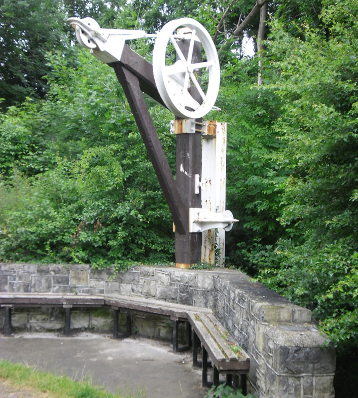
Railway Ramblers – Blaenavon to Pontypool
This walk was formerly part of the direct rail route from Brynmawr to Newport. The 3’ 4” gauge Blaenavon Tramroad opened in 1795 from the canal at Pontnewynydd to Blaenavon Ironworks with branches to ironworks and collieries at Abersychan, Varteg and Cwm Ffrwd. The Monmouthshire Railway and Canal Company opened a standard gauge branch mainly on its course to freight in 1854.
Part of NCN route 46, the walk follows the double track railway formation from the World Heritage Site at Blaenavon on a steady descent of over 650 feet down to Pontypool, initially alongside the Pontypool and Blaenavon Heritage Railway. Fork left as the trackbed of the mineral line to Varteg Hill Collieries climbs away to the right and evidence of neighbouring and connecting lines can be noted along the route with some impressive infrastructure.
The station site at Varteg is clearly identifiable, although no buildings remain. However, at Abersychan and Talywain, the passenger station and goods shed both survive. At Pentrepiod, the line takes a large horseshoe curve with spectacular viaducts crossing the former Cwmnantddu and Cwmffrwdoer mineral branches.
Descending into Pontypool, the old railway route has been lost to road development but you can continue along the cycle path which runs alongside to a roundabout near the site of Pontypool Crane Street station. From here, you can head to bus stops in the town centre for onward travel.
Railway Ramblers is a national club that organises walks and encourages interest in disused railway lines throughout the UK. New members who enjoy walking trails in a friendly group with knowledgeable walk leaders are welcome to join – find out more here.

Louis Mertens, TfW Community Engagement Officer – Barmouth to Dolgellau
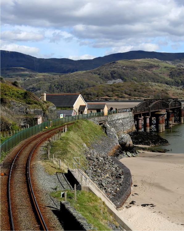
It is not hard to imagine that the rail route between Barmouth and Dolgellau might have at one time been one of the most beautiful in Wales. Crossing the longest timber viaduct in Wales and following the estuary of the Afon Mawddach east into the quaint town of Dolgellau, the route is now perfect for a walk or cycle away from the hustle and bustle of Barmouth sea front.
The route is flat, for the most part - you certainly wouldn’t register the gradient underfoot. Whilst the walk is a long 9.4 miles from Barmouth to Dollgellau, you can cycle there and back in under 2 ½ hours. The route is mostly gravel, but there are a handful of points that have the potential to get muddy in poor weather. Those wishing to make a day of it can take a well-timed pit stop at the George III Hotel, an ex-ship chandler dating from 1650, situated on the banks of the estuary about three-quarters of the way into the first leg in the village of Penmaenpool.
As you leave Barmouth, passing the Birmingham Garage on your left, follow the narrow path up the road until you see the bright blue sign for Barmouth Bridge pointing right. There is no crossing here and a pavement only on one side of the road, so cross with care. This leads to quite a steep slope, descending to Barmouth Bridge. If you time the start of your trip carefully, you might find yourself sharing the bridge with one of our trains bound for Pwllheli or Machynlleth.
Follow the viaduct across the estuary. If you choose to cycle be mindful that this space is shared with pedestrians, and the wooden boards on the bridge are quite rickety. The sweeping views from the centre of the bridge are spectacular. Once you come to the end of the viaduct, continue to follow the rail line for about a mile until the path carries you away in the direction of a blue sign that says Mawddach Trail. Continue to follow the trail through a wooded section, you’ll come to a road crossing, gated on both sides, with the trail signposted. Continue straight on.
By this point, it is difficult to lose the trail so long as you continue to follow the path, which will follow the estuary closely for just over 2 miles. The trail will start to bring you away from the water and through the flats – the view remains breathtaking. Passing the George III Hotel on your right, go straight past the bridge on your left (don’t cross over it) continue through the car park where the trail continues and is signposted. Whilst the George III Hotel was originally a ship-chandler and pub (c. 1650), what is now an annexe to the hotel was previously the station master’s house, ticket office and waiting room for Penmaenpool station.
Continue to follow this path for just over a mile until it intersects with a road. You’ll notice a roundabout on your left, this road can get busy and is fast so take care You don’t need to enter the road, as the pavement on the right as you reach the junction is shared with cyclists. The trail is signposted again on the other side of the road. Cross the road at the marked point, and continue to follow the blue Mawddach trail signage. The trail now follows the Afon Wnion, a tributary of the Mawddach you began on. You will soon come to a fork in the path, take a right, crossing a bridge over the Wnion and following the path past the rugby field and into Dolgellau.

Barmouth Bridge
James Bennett, TfW Communications Officer – Taff’s Well to Caerphilly and Pontypridd
The Taff Trail is renowned throughout South Wales as being one of our best active travel routes, linking Cardiff with the valleys by following the scenic River Taff. But did you know that much of the route is actually a former railway line?
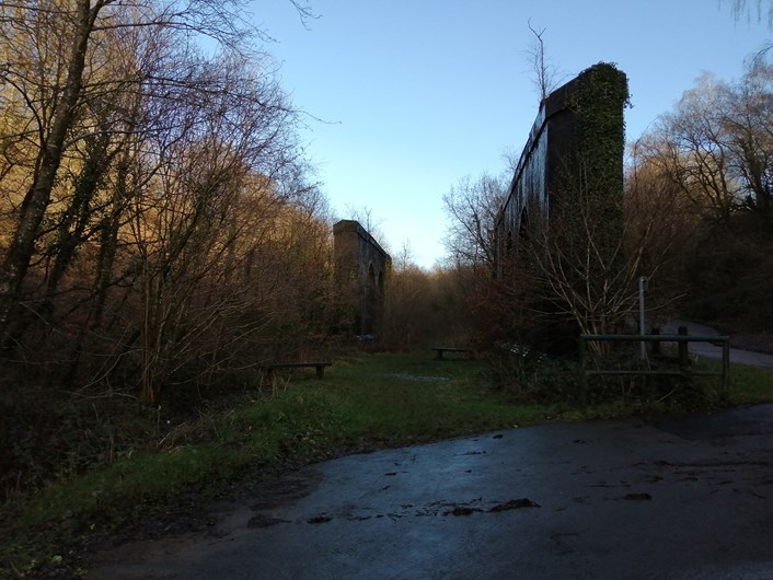
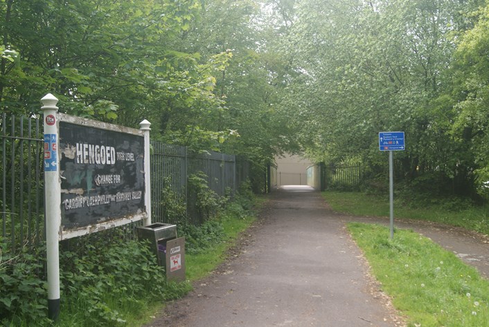
As you leave Taffs Well station, take a left turn past the site of our new South Wales Metro depot and you will reach the original route of the Rhymney Railway, known locally as “Big Hill”. This climb – which was steep for trains but relatively flat for walkers and cyclists – takes the route across the A470 and above the Taff Vale, affording spectacular views up the valley. Eventually the route enters Penrhos Cutting, a deep gorge dug out by navvies during the explosion of railway construction in the nineteenth-century and a focal point for a number of railway lines in the area, which all met here at Penrhos Junction.
Keep walking and you eventually reach a number of brick pillars on the outskirts of Caerphilly. This was once a flyover bridge that took the Barry Railway – a later rail route built to link collieries with the new Barry Docks – over the Rhymney Railway. This became one of the most famous landmarks in the South Wales valleys rail network, even after the bridge was dismantled following closure of the railway in 1926. From here, it’s a short walk into the centre of Caerphilly, where you can visit the world-renowned castle.
The Taff Trail itself branches off this route at Nantgarw, crosses the main road between Taff’s Well and Caerphilly, and heads towards Pontypridd. This itself is another former railway link, the Pontypridd, Caerphilly and Newport Railway, which was built to link the valleys to Alexandra Dock in Newport. The railway had so little regard for passengers that the stations along the line were built without platforms, with passengers having to climb onto the trains from ground level!
Along here, you can find yourself in splendid isolation on the hillside above Upper Boat until reaching Rhydyfelin, where the railway began to take a winding route on the approach to Pontypridd. The A470 has been built over the last section of line, so you can only walk along the line as far as Glyntaff, but the Taff Trail continues into the popular Ynysangharad Park in Pontypridd town centre, home of the National Lido of Wales – time for a quick splash before heading back down the valley?